|
Spatial Filter filters the data by a shape that you draw on the map.
•Polygon
•Rectangle
•Circle
A description of each type of shape follows.
A. Draw a Polygon Spatial Filter
This filter lets you draw a polygon on the map by clicking points. All features within that polygon are included in the filter.
1.Make sure the Condition Map is visible.
2.Click the Filter by Shape icon from the spatial toolbar on the right: 
3.The Filter by Shape toolbar expands:

4.Select the Draw a polygon icon: 
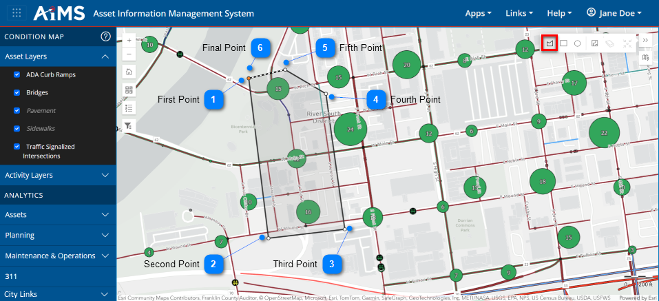
5.The cursor becomes a "+" sign. Draw a polygon by following the numbered instructions beneath the illustration.
|

|
First Point
|
|
Position the cursor and click a location where you want to drop the first point that will define the polygon.
|
|

|
Second Point
|
|
Click to drop the second point.
|
|

|
Third Point
|
|
Click to drop the third point.
|
|

|
Fourth Point
|
|
Click to drop the fourth point.
|
|

|
Fifth Point
|
|
Click to drop the fifth point. NOTE: You can continue dropping as many points as needed to define the outline of the polygon.
|
|

|
Final Point
|
|
Double-click the last location to close the polygon. NOTE: This does not have to be the same location as the first point. The polygon is now defined and its interior appears pale gray.
|
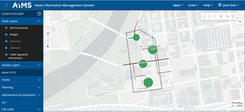
6.Once the polygon is defined, the map zooms to the polygon you drew and all features inside the polygon are included in the filter.
NOTE: If the area within the polygon contains more than 10,000 features, you will get a warning message. You will have to clear the filter and draw a smaller polygon.
NOTES:
•If you happen to click Zoom Out and then want to zoom back into the polygon, click the Zoom to selection icon:
•If you want to save the polygon filter and use it in the future, see: Save Attribute and Spatial Filters.
•If you want to clear the polygon filter and start over, click Clear Spatial Filters: 
B. Draw a Rectangle Spatial Filter
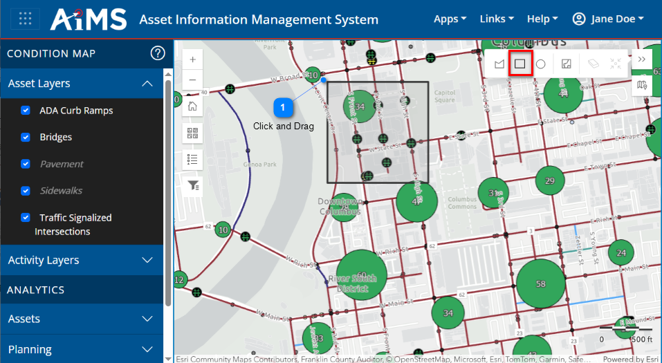
This filter lets you draw a rectangle on the map by clicking the cursor to indicate one corner and dragging the cursor diagonally indicate the opposite corner. All features within that rectangle are included in the filter. Follow the instructions below the illustration.
1.Make sure the Condition Map is visible.
2.Click the Spatial Filter icon from the spatial toolbar on the right:
3.The Spatial Filter toolbar expands:
4.Select the Draw a rectangle icon: 
5.The cursor becomes a "+" sign. Draw a rectangle by following the numbered instructions beneath the illustration.
|

|
Click and Drag
|
|
a.Click and hold down the mouse button at a location indicating the corner of the rectangle.
b.Drag the cursor diagonally to expand the rectangle.
c.Release the mouse button to complete the rectangle.
NOTE: Press and hold Ctrl and Shift keys on your keyboard to draw a square shape.
|
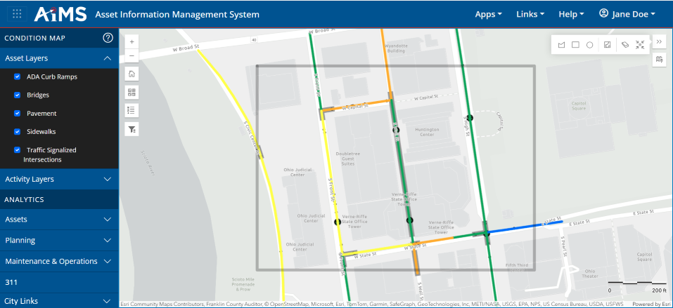
6.Once the rectangle is defined, the map zooms to the rectangle you drew and all features inside the rectangle are included in the filter.
NOTE: If the area within the rectangle contains more than 10,000 features, you will get a warning message. You will have to clear the filter and draw a smaller rectangle.
NOTES:
•If you happen to click Zoom Out and then want to zoom back into the rectangle, click the Zoom to selection icon:
•If you want to save the rectangle filter and use it in the future, see: Save Attribute and Spatial Filters.
•If you want to clear the rectangle filter and start over, click Clear Spatial Filters:
C. Draw a Circle Spatial Filter
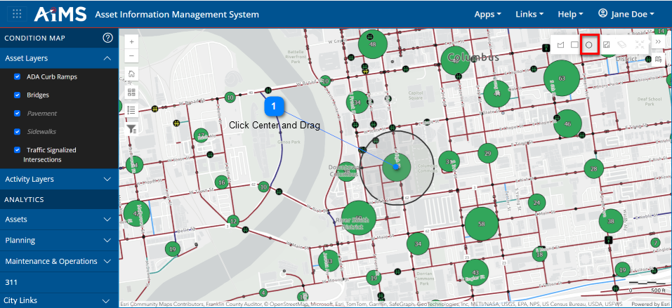
This filter lets you draw a circle on the map by clicking the cursor to indicate the center and dragging the cursor to indicate the radius. All features within that circle are included in the filter.
1.Make sure the Condition Map is visible.
2.Click the Filter by Shape icon from the spatial toolbar on the right:
3.The Filter by Shape toolbar expands:
4.Select the Draw a circle icon: 
5.The cursor becomes a "+" sign. Draw a circle by following the numbered instructions beneath the illustration.
|

|
Click Center and Drag
|
|
a.Click and hold down the mouse button at a location indicating the center of the circle.
b.Drag the cursor outward to define the radius of the circle.
c.Release the mouse button to complete the circle.
NOTE: Press and hold Ctrl and Shift keys on your keyboard to draw an oval shape.
|
6.Once the circle is defined, the map zooms to the circle you drew and all features inside the circle are included in the filter.
NOTE: If the area within the circle contains more than 10,000 features, you will get a warning message. You will have to clear the filter and draw a smaller circle.
.png)
NOTES:
•If you happen to click Zoom Out and then want to zoom back into the circle, click the Zoom to selection icon:
•If you want to save the circle filter and use it in the future, see: Save Attribute and Spatial Filters.
•If you want to clear the circle filter and start over, click Clear Spatial Filters:
|

