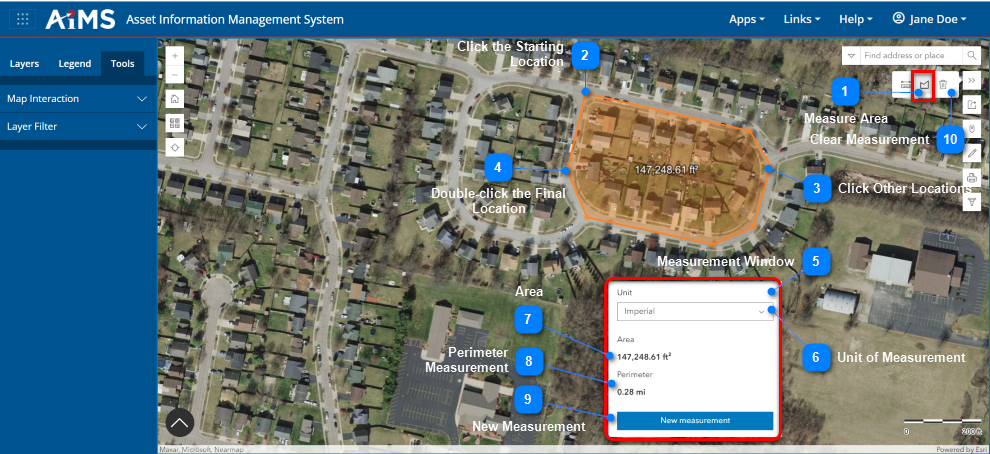
The Area tool is one of the Measure tools. It is an interactive tool that returns the area and perimeter of a closed polygon that you define by clicking locations on the map. NOTE: The returned value can also be displayed in different units of measurement.
Follow the numbered instructions beneath the illustration to make an area measurement.
Measure Area
Click the Measure icon in the vertical toolbar:
Then click the MeasureArea icon in the expanded Measure toolbar.
Click the Starting Location
Click a starting location on the map.
Click Other Locations
Click additional locations to add points to the polygon; as you do so, the sides of the polygon are defined. You need a minimum of three points to create a polygon. NOTE: If the Measurement Window is in the way of clicking a location, click and drag to move the map until you are able to click another location.
Double-click the Final Location
Double-click the final location to complete the polygon. NOTE: This does not have to be the same location as the starting point. NOTE: This location should NOT be the same as the starting location, nor should it be extremely close to the starting location. Otherwise, the system will not know you are finished defining the distance.
Measurement Window
The total area and perimeter of the polygon are displayed in the pop-up Measurement window.
Unit of Measurement
If desired, change the unit of measurement by selecting a new unit from the drop-down list
Area
View the area of the defined polygon. The area measurement is displayed in the selected unit of measure.
Perimeter Measurement
View the perimeter of the defined polygon. The perimeter measurement is displayed in the selected unit of measure.
New Measurement
Clear the polygon from the map, clear the area/perimeter measurements from the Measurement window, AND begin a new measurement session (without having to click the Measure Area icon again).
Clear Measurement
Clear the polygon from the map, clear the area/perimeter measurements from the Measurement window, AND end the area measurement session.