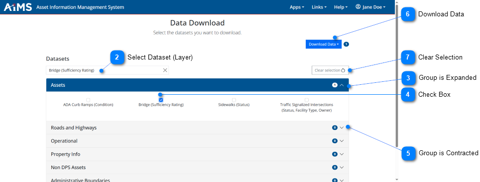
The Access Data module of the AIMS application allows you to export data to local file formats.
NOTE: Access Data offers four types of file formats for exporting data: CSV, File Geodatabase, and Shapefile. Data must be available for export in Portal for ArcGIS.
Follow the numbered instructions below the illustrations to export data.
Access Data
From the AIMS home page, click the Access Data button to display the Access Data module.
Select Dataset (Layer)
Go to the Datasets drop-down list and select the layer whose data you want to download. In this example, it is: Bridge (Sufficiency Rating).
Group is Expanded
The group containing the selected layer automatically opens. You see any other layers associated with that group. In this example, the expanded group is Assets.
•If you want to expand other groups, click the down arrow on the right side of the group name.
Check Box
Click the check box next to any layer you want to download. In this example, the selected layer is: Bridge (Sufficiency Rating).
•You can now select other layers in that group as well. As you do so, a number appears to the far-right of the group name, indicating how many layers are selected in that group.
•If you make a mistake, re-click the check box to remove the check mark.
Group is Contracted
If you want to select another layer from a different group, click the down-arrow next to the group name. In this example, the contracted group is: Roads and Highways. The group will then expand to display its associated layers. You can now select any of those layers.
Download Data
Once all the layers of interest are selected (have check marks next to them), click the Download Data button.
•A drop-down menu appears where you must select the export file format: CSV, File Geodatabase, KML, or Shapefile.
•A number next to the Download Data button lets you know how many layers will be downloaded. In this example, 1 layer will be downloaded.
•If multiple datasets are selected for download they will all be combined into one zip file.
Clear Selection
Click Clear Selection to remove all selected items after the download is done.
IMPORTANT!
•Some datasets are not set up for Data Download and will trigger the following warning message:
•If you get this message, contact your AIMS administrator for assistance.


.png)
-number-1.png)